【背景资料】甲铁矿为地下矿山,共有员工780人,拟对该矿的尾矿库进行加高扩容工程四期建设,该尾矿库采用湿式放矿、上游式筑坝,等别为二等。2023年1月,委托某安全评价公司完成了《安全预评价报告》,2023年1月24日,该矿组织专家对《安全预评价报告》进行了评审并予以通过。2023年3月,该矿委托某设计院出具《变更安全设施设计》。2023年4月,有关安全生产监督管理机关组织通过了《变更安全设施设计》评审。2023年4月25日该矿以包工包料形式委托给乙公司组织施工。
2023年5月10日开始施工。2024年3月11日中班,乙方项目部安排朱某、成某等6名工人,在坝上进行膜袋灌沙、扎口及排水作业,18时30分,甲方夜班巡坝工严某、郭某按照班组管理制度要求到达现场进行了正常交接班,2人均按照巡检周期(2h)对坝体进行巡查一次,巡查过程中未见异常情况。12日凌晨2时10分正在进行膜袋施工的朱某和成某,发现其所处工作区域(北部)的坝体开始下沉。
凌晨2时20分,郭某再次上坝检查时,发现尾矿库西北段坝体溃塌,立刻向调度员李某报告,李某立即向车间主任张某报告。事故发生后,当地市政府第一时间启动应急响应。溃口于3月24日实现合拢,开始进入坝面调平加高阶段,基本完成尾砂坝临时处置工程。
事故淹没下游鱼塘近400亩,造成下游居民2人死亡,1人失联。
经事故调查发现:该尾矿库坝体溃坝段底部为采空区,采空区的顶板花岗岩经长期风化侵蚀而坍塌。甲铁矿关于尾矿库管理的安全生产责任制和安全管理制度长期缺失,没有明确管理人员和巡坝人员职责。安全投入不足,没有严格按照规定提取使用安全费用。对坝体的安全监测如位移等监控设施布设间距不符合规定。每年的员工全员培训内容,仅包含劳动防护用品的穿戴。同时安全管理人员和技术人员缺乏,人员配备不足。
根据以上场景,回答下列问题(共22分):
根据资料(1)和(2),2023年6月30日摊销合同取得成本为( )万元。
5.4
6
18
1.2
【背景资料】
某施工单位承担某新建高速铁路站前工程第四标段的施工任务,工程内容包括第四标段的路基、桥梁、隧道以及全线的铺轨。主要工程情况如下:
路基及站场土石方共279万m3。
双线桥梁1座,上部结构为168-32整孔预制简支箱梁,下部结构为钻孔桩基础。在56#~59#墩处,通过框架墩和简支箱梁上跨既有电气化铁路,框架墩为钢筋混凝土墩身、钢横梁。
双线隧道1座,长6360m,设一座斜井。隧道进、出口工区的围岩级别为Ⅲ~V级,部分地段节理裂隙很发育,呈裂隙块状结构;斜井工区的围岩级别为Ⅱ、Ⅲ级。根据招标文件要求,隧道进、出口工区采用基本机械化配套施工,斜井工区采用大型机械化配套施工,技术人员拟配备的斜井工区大型机械化配套如表4所示。
项目总工程师审核后认为开挖作业线、初期支护作业线和衬砌作业线中的大型设备不全。在进口工区施工至距离洞口320处,现场技术人员发现隧道掌子面前方有不良地质前兆:节理组数急剧增加,出现岩层牵引褶曲,岩石强度明显降低,有少量渗水。
全线一次铺设跨区间无缝线路,除长隧道内设计为双块式无砟轨道外,其他地段均为有砟轨道,铺轨基地设在相邻第三标段的既有车站附近。正线有砟轨道403.85铺轨公里,无砟轨道13.96铺轨公里;站线有砟轨道7.76铺轨公里;铺道岔66组。正线有砟轨道采用单枕法铺设长钢轨,站线采用人工铺轨,根据施工计划,正线铺设长钢轨有效施工工期为180天。技术人员列出的正线铺轨重难点工序有:长轨焊接、道岔铺设、上砟整道,项目总工程师审核后认为列出的重难点工序不全,需要补充。
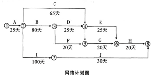
【背景资料】某工程项目、地上15~18层,地下2层,钢筋混凝土剪力墙结构,总建筑面积57000m。施工单位中标后成立项目经理部组织施工。项目经理部计划施工组织方式采用流水施工,根据劳动力储备和工程结构特点确定流水施工的工艺参数、时间参数和空间参数,如空间参数中的施工段、施工层划分等,合理配置了组织和资源,编制项目双代号网络计划如图3-1。
项目经理部上报了施工组织设计,其中:施工总平面图设计要点包括了设置大门,布置塔吊、施工升降机,布置临时房屋、水、电和其他动力设施等。布置施升降机时,考虑导轨架的附墙位置和距离等现场条件和因素。公司技术部门]在审核时指出施工总平面图设计要不全,施工升降机布置条件和因素考虑不足,要求补充完善项目经理部在工程施工到第8月底时,对施工进度进行了检查,工程进展状态如图3-1中前锋线所示。工程部门根据检查分析情况,调整措施后重新绘制了从第9月开始到工程结束的双代号网络计划,部分内容如图3-2。
主体结构完成后,项目部为结构验收做了以下准备工作:
(1)将所有模板拆除并清理干净;
(2)工程技术资料整理、整改完成。
(3)完成了合同图纸和洽商所有内容;
(4)各类管道预埋完成,位置尺寸准确相应测试完成;
(5)各类整改通知已完成,并形成整改报告。项目部认为达到了验收条件,向监理单位申请组织结构验收,并决定由项目技术负责人、相关部门经理和工长参加。监理工程师认为存在验收条件不具备、参与验收人员不全等问题要求完善验收条件。
某股份有限公司首次公开发行股票5亿股,采用询价方式定价,并向战略投资者配售。本次公开发行股票时,投资者申购十分踊跃,网下投资者申购数量超过网下初始发行量,网上投资者的有效申购倍数为120倍。
[A] Some archaeological sites have always been easily observable—for example, the Parthenon in Athens, Greece; the pyramids of Giza in Egypt; and the megaliths of Stonehenge in southern England. But these sites are exceptions to the norm. Most archaeological sites have been located by means of careful searching, while many others have been discovered by accident. Olduvai Gorge, an early hominid site in Tanzania, was found by a butterfly hunter who literally fell into its deep valley in 1911. Thousands of Aztec artifacts came to light during the digging of the Mexico City subway in the 1970s.
[B] In another case, American archaeologists René Million and George Cowgill spent years systematically mapping the entire city of Teotihuacán in the Valley of Mexico near what is now Mexico City. At its peak around AD 600, this city was one of the largest human settlements in the world. The researchers mapped not only the city’s vast and ornate ceremonial areas, but also hundreds of simpler apartment complexes where common people lived.
[C] How do archaeologists know where to find what they are looking for when there is nothing visible on the surface of the ground? Typically, they survey and sample (make test excavations on) large areas of terrain to determine where excavation will yield useful information. Surveys and test samples have also become important for understanding the larger landscapes that contain archaeological sites.
[D] Surveys can cover a single large settlement or entire landscapes. In one case, many researchers working around the ancient Maya city of Copán, Honduras, have located hundreds of small rural villages and individual dwellings by using aerial photographs and by making surveys on foot. The resulting settlement maps show how the distribution and density of the rural population around the city changed dramatically between AD 500 and 850, when Copán collapsed.
[E] To find their sites, archaeologists today rely heavily on systematic survey methods and a variety of high-technology tools and techniques. Airborne technologies, such as different types of radar and photographic equipment carried by airplanes or spacecraft, allow archaeologists to learn about what lies beneath the ground without digging. Aerial surveys locate general areas of interest or larger buried features, such as ancient buildings or fields.
[F] Most archaeological sites, however, are discovered by archaeologists who have set out to look for them. Such searches can take years. British archaeologist Howard Carter knew that the tomb of the Egyptian pharaoh Tutankhamun existed from information found in other sites. Carter sifted through rubble in the Valley of the Kings for seven years before he located the tomb in 1922. In the late 1800s British archaeologist Sir Arthur Evans combed antique dealers’ stores in Athens, Greece. He was searching for tiny engraved seals attributed to the ancient Mycenaean culture that dominated Greece from the 1400s to 1200s BC. Evans’s interpretations of these engravings eventually led him to find the Minoan palace at Knossos (Knosós), on the island of Crete, in 1900.
[G] Ground surveys allow archaeologists to pinpoint the places where digs will be successful. Most ground surveys involve a lot of walking, looking for surface clues such as small fragments of pottery. They often include a certain amount of digging to test for buried materials at selected points across a landscape. Archaeologists also may locate buried remains by using such technologies as ground radar, magnetic-field recording, and metal detectors. Archaeologists commonly use computers to map sites and the landscapes around sites. Two- and three-dimensional maps are helpful tools in planning excavations, illustrating how sites look, and presenting the results of archaeological research.
41. |
| → | A | → | 42. |
| → | E | → | 43. |
| → | 44. |
| → | 45. |
|